Following almost 30 years of service, the European Space Agency’s ERS-2 satellite re-entered Earth’s atmosphere at approximately 18:17 CET on February 21.
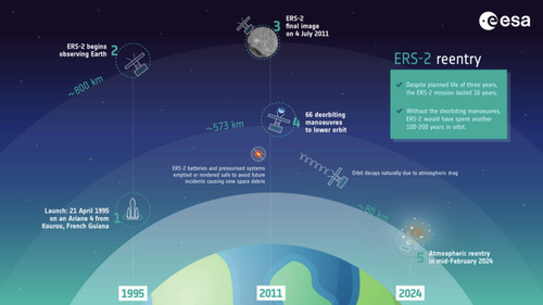
Launched in 1995 and with an original mission life of just three years, ERS-2 set new standards for Earth observation, collecting valuable data on the ozone layer, ocean temperature, and mankind’s overall impact on the planet.
In 2011, ESA decided to initiate the satellite’s deorbiting process amid concerns over the increasing amount of space junk. That process came to an end last week.
ERS-2 arrived back to Earth about six hours later than ESA had predicted. In fact, as this was an uncontrolled, natural re-entry, it was impossible to determine the exact time and place of return.
Below you can see the full journey of ERS-2, from launch to re-entry:


The Tracking and Imaging Radar (TIRA) at the Fraunhofer Institute in Germany captured the final images of the satellite. TIRA’s antenna tracked ERS-2 on February 19, 20, and 21 — with the final pictures taken roughly 10 orbits before re-entry.
This GIF combines some of the last images taken across the three days:
ESA compared the different images and saw that the satellite’s solar array was breaking loose from the main body already the day before its return. This may have caused the satellite to interact with the atmosphere in unexpected ways.
Data analysis will also show if the solar array’s detachment was related to the later return, which could improve forecasts for future natural re-entries.
Nevertheless, ESA’s in-orbit missions are now designed for controlled re-entries, so that operators can ensure that satellites arrive back over widely unpopulated areas such as the South Pacific Ocean. ERS-2 re-entered over the North Pacific Ocean and broke into pieces with no damage to property reported.

