Article content
March weather was both lion and lamb in Canada on Monday, with Toronto residents dining al fresco in sun-splashed parks while Saskatoon residents carved paths through snow drifts deep enough to swamp automobiles.
Advertisement 2
Article content
Environment Canada said the temperature in Toronto hit 14 C by the afternoon, surpassing the highest temperature on record for the city on a March 4, which was 13.3 C in 1974.
Article content
Many were seen enjoying the afternoon weather in Toronto, with some taking their lunch outdoors to enjoy the unseasonable warmth.
Sarah Nasan said she decided to enjoy the outside instead of eating in her office.
“It’s great to be able enjoy warm sun,” she said. “It feels like spring … I like having my lunch in the park.”
Environment Canada meteorologist Geoff Coulson said temperatures in Toronto were expected to climb even higher Tuesday.
“The overall weather pattern for Toronto and actually all of southern and central Ontario is (due to) a flow from the south bringing in warm, very warm (temperatures) and record-breaking warmth,” he said in a phone interview.
Article content
Advertisement 3
Article content
“We’re forecasting a high of 16 degrees on Tuesday. The current record for March 5 right now is 18.5 degrees set back in 2004, so that record may be safe.”
Coulson said other cities in Ontario were also seeing near-record or record-breaking temperatures Monday.
“We could be looking at many locations across southern and central Ontario breaking records,” he said.
“In the southwest, we’re looking at places like Windsor and London, Sarnia, Kitchener, and then east of Toronto: Peterborough, Ottawa, Sudbury in central Ontario. All of these places right now have records that are at risk.”
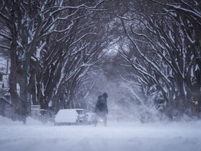
Heading West, Mother Nature went from sunny to snarly as residents dug out from a weekend storm and Environment Canada issued a snowfall warning for parts of northern Saskatchewan and northern Manitoba.
Advertisement 4
Article content
Up to 20 centimetres of the white stuff was expected in some regions before tapering off Monday evening.
In Saskatoon, residents took to social media to thank volunteer “snow angels” for tackling the drifts, snowblowing paths for neighbours to get out of their homes or to their cars.
Many vehicles parked on streets were cast adrift in the drifts, nearly buried under tall peaks of show sculpted by roaring icy winds.
Snowplows, graders and sanders relentlessly hummed throughout the day, clearing city streets and parking lots.
Many families took a snow day after classes were cancelled for some schools.
A full fleet of Saskatoon transit buses was back in business, but the city warned there could be detours and delays as drivers tried to navigate accessible streets.
Advertisement 5
Article content
Environment Canada meteorologist Terri Lang said the hardest-hit areas of Saskatchewan were in the west-central region, including Saskatoon and through to North Battleford.
In Manitoba, snow also brought delays and shutdowns for drivers and students.
Sections of many highways were closed Monday morning due to poor visibility and swirling snow, while several school divisions, including Lord Selkirk, Hanover, Sunrise, Red River and Brandon, shut schools for the day.
Brandon University’s main campus also cancelled classes. The university said most offices and campus services were closed. The Winnipeg campus remained open.
Crews worked to restore power after thousands on Sunday were left without functioning energy connections in Winnipeg and other communities.
In Alberta, Edmonton residents gritted their teeth and pulled tuques down tighter as icy winds roared down the main street of Jasper Avenue during the morning rush hour.
An extreme cold warning was in effect for large parts of Alberta, with wind chill values approaching -40.
— With files from Brittany Hobson in Winnipeg and Kelly Geraldine Malone in Saskatoon
Article content


