Wildfire fighting and forest management decisions are potentially being hampered by inaccurate government data that misrepresents forest fuel loads in British Columbia’s Interior, a new study has found.
The B.C. government says the provincial wildfire service is working with the study’s lead author and others to close the data gap, which involves “mismatches” between remotely-sensed mapping, forest fuel classifications and observations on the ground.
“These mismatches make it difficult for fire managers to accurately determine expected fire behaviour before an event occurs,” the researchers say in the study published in the peer-reviewed journal Fire Ecology last month.
The mismatches may also result in failure to identify at-risk areas that would benefit from work to mitigate the fuel buildup, the paper says.
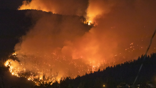
The wildfires in Lahaina, Lytton and West Kelowna that displaced residents and destroyed homes seemed to come out of nowhere. We break down the environmental and meteorological factors that can affect how fast a fire moves and how quickly it can spread.
Understanding the mix of flame-stoking grasses, branches and dead trees in the forest is crucial to managing risk, because those fuels are the only factors that people can change in the short term to influence fire behaviour, it says.
The researchers from the University of B.C. and Canadian Forest Service acknowledge that mapping forest fuels is “notoriously challenging” despite its importance in influencing and predicting wildfire behaviour.
‘Poor correspondence’ between observations, data
Lead author Jen Baron says fixing the data will help officials identify and respond to fire-prone areas, though will likely require a “huge lift.”
“The challenge is that we’re trying to use these fuel-type maps to decide where to put fuel treatments,” she says, referring to measures such as prescribed burning, thinning dense forests or burning piles of “slash” following logging.
The study comes after Canada suffered its most-destructive fire season ever recorded, which burned more than 180,000 square kilometres by the end of September 2023, including more than 28,000 square kilometres of land in B.C., where hundreds of homes were destroyed in the Okanagan and Shuswap regions.
Baron said improving how experts map various fuel types will help researchers and wildfire officials understand how fuels interact with today’s environmental conditions, and with each other, to influence fire behaviour, Baron says.
“What we really need to be able to do is link the fuel conditions, the fire behaviour,” Baron, a sessional lecturer at the department of forest and conservation sciences at the University of B.C., explained. “Things like the rate of spread, the intensity, the flame length — and the weather, so we can understand how they all work together under different scenarios.”
The paper found “poor correspondence” between field observations and government data, specifically B.C.’s vegetation resource index and the national fire behaviour prediction system.
The researchers identified 76 plots in an area known as the Rocky Mountain Trench separating the Columbia and Rocky Mountain ranges in southeastern B.C.
They found “no suitable match” between national system’s data and field observations in 58 per cent of the one-hectare plots. A further 42 per cent were “partially suitable,” the paper says.
The national and provincial forest inventory data are largely derived from aerial imaging, and Baron says it was “significantly underestimating” the density of underbrush that serves as a conduit for flames travelling up to the forest canopy.
Problems with prediction system
The study also revealed problems with Canada’s fire behaviour prediction system when it comes to classifying fuel types in B.C.’s Interior, Baron says.
The existing system uses data from a series of experimental burns 60 years ago, when fire weather and fuel beds were “very different than they are today,” she says.
It was also designed primarily to inform fire suppression in boreal forests and uses 16 fuel types to represent conditions throughout Canada, Baron says.
“There just really aren’t enough fuel types to represent the diversity of conditions that we have in Interior B.C.”
One example of a mismatch could be an area with a fuel type listed as mature lodgepole pine forest, but if it had been logged, leaving a buildup of “slash,” Baron says the system may not capture the real fuel load and potential risk.
The provincial wildfire service uses the existing fuel-type mapping, but officials are aware of its limitations and use their own expertise and observations to make decisions about fire suppression and fuel mitigation efforts, she adds.
In an emailed statement, the Forests Ministry says the B.C. Wildfire Service is working with Baron and other researchers to improve fuel classification.
This spring, Baron will look at how fire behaviour specialists are using the existing data in combination with local knowledge to “calibrate their predictions,” it says.
The B.C. government is also working to improve its forest inventory data by acquiring LiDAR mapping for the whole province. Short for “light detection and ranging,” the aerial mapping process using laser-based technology.
Still, Baron says researchers will also need data from the field, in finer detail than LiDAR can offer, as well as data on fire behaviour under different conditions.
The ministry statement says the B.C. Wildfire Service has “expanded the research element” of prescribed burning, and fire behaviour observers will accompany front line teams to collect data from active blazes.


